Red Copy Survey, Why you must have it!
28 April 2026
A survey plan and a record copy survey are essential documents related to land ownership and property boundaries. Let’s explore what these documents are and their significance.
A Survey Plan and a Record Copy Survey (commonly called the “Red Copy”) are important technical documents in land documentation in Nigeria. Below is a clear and accurate explanation of what they are and why they matter.
What is a Survey Plan?
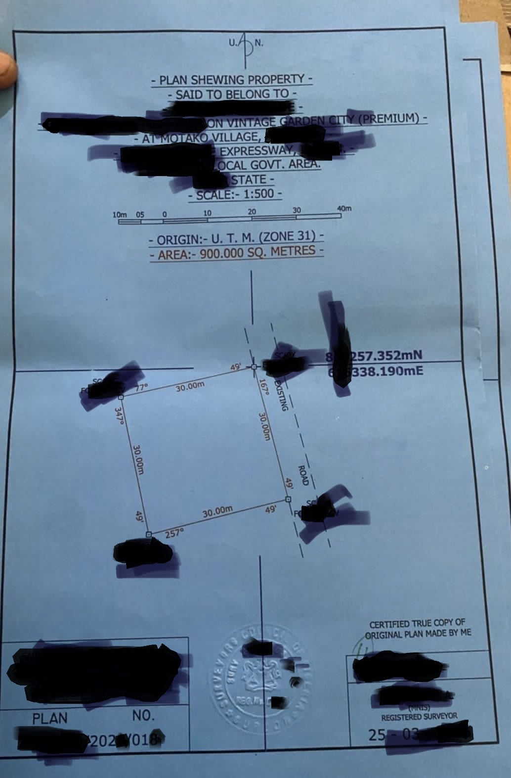
A Survey Plan is a graphical representation of a piece of land, prepared by a licensed surveyor registered with the Surveyors Council of Nigeria (SURCON). It shows the exact boundaries, dimensions, beacons, and features of the property.
Key elements usually included:
Accurate measurements of boundaries and angles
Identification of neighbouring properties and landmarks
Location of existing structures (if any)
Legal notations and surveyor’s seal
A Survey Plan is essential when buying land, developing property, or resolving boundary issues. It helps ensure the physical land matches the description in your transaction documents.
What is a Record Copy Survey (Red Copy)?
The Record Copy, commonly called the “Red Copy”, is the officially lodged version of a survey plan at the Surveyor General’s Office in the state where the land is located. Once a licensed surveyor prepares and signs the survey plan, it can be submitted to the Surveyor General’s Office for recording purposes. When successfully lodged, a certified Record Copy is issued as the official archival version kept by the government.
Important Clarification:
A Record Copy Survey is not a title document and does not prove legal ownership of the land. It is a technical supporting document that provides an authoritative definition of the land’s boundaries.
Why You Should Have a Record Copy Survey
Here are the practical benefits:
a. Clear Boundary Definition
It provides a precise, professionally verified record of your land’s boundaries, reducing the risk of disputes with neighbours.
b. Supporting Document for Title Perfection
A Record Copy is usually required when applying for or processing formal title documents such as a Certificate of Occupancy (C of O) or Governor’s Consent. It forms part of the complete documentation package.
c. Preventing and Resolving Disputes
In Nigeria’s real estate market, boundary conflicts are common. A registered Record Copy serves as strong reference evidence in case of disagreements.
d. Facilitating Transactions and Loans
Banks and financial institutions often request a Record Copy Survey (along with other documents) when evaluating property for mortgages or loans, as it helps verify the physical extent of the land.
e. Guiding Development and Infrastructure
Developers, architects, and builders rely on accurate survey data to plan projects without encroaching on adjacent properties or violating setbacks.
f. Regulatory Compliance
Many government agencies require a proper survey plan or Record Copy for building plan approvals, land use applications, and other regulatory processes.
g. Property Valuation
Valuers use the verified measurements and boundaries in the survey to determine the accurate market value of the land.
Key Takeaways
A Survey Plan identifies your land.
A Record Copy (Red Copy) is the lodged version that strengthens your documentation file.
Neither document is a title or proof of ownership.
Always engage a SURCON-licensed surveyor for your land survey needs. Using qualified professionals helps avoid quacks and ensures your documents meet required standards.
Note: Procedures may vary slightly across states in Nigeria. For accurate guidance, consult a licensed surveyor in your location or visit the relevant Surveyor General’s Office.
Digit Properties Team
Helping Nigerians secure their land the right way.
We remain committed to accurate public education on land documentation and will continue to refine our materials based on professional input and legal clarifications.